
Understanding aeronautical search, rescue

The disappearance of Malaysia Airlines Flight 370 operated by a Boeing 777 – 200ER on March 8, 2014, while flying from Kuala Lumpur International Airport in Malaysia to its planned destination, Beijing Capital International Airport in China, is regarded as the greatest mystery in aviation history.
The multinational search effort using ships and aircraft from Malaysia, China, India, Japan, Australia, New Zealand, South Korea, Vietnam, the UK and US was the most expensive aviation search.
The search began in the Gulf of Thailand and the South China Sea, where the aircraft's location was last detected on secondary surveillance radar (SSR) and was soon extended to the Strait of Malacca and Andaman Sea. Analysis of satellite communications between the aircraft and Inmarsat's satellite communications network concluded that the aircraft flew far southward over the southern Indian Ocean.
On March 24, 2014, the Malaysian government noted the final location determined by the satellite communication was far from any possible landing sites and concluded: "Flight MH370 ended in the southern Indian Ocean."
After a three-year search across 46,000 square miles of ocean failed to locate the aircraft, the Joint Agency Co-ordination Centre heading the operation suspended its activities in January 2017.
This incident brought to the forefront the limitations of ground-based aircraft surveillance systems such as SSR and ADS-B, both of which have an effective range of 250 nautical miles.
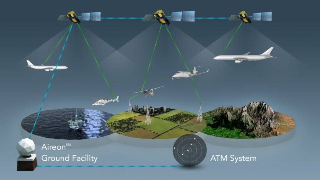
Graphic courtesy Aireon -
Aircraft fly across large areas of water, desert and mountainous terrain outside the range of SSR.
Aircraft communicate with ATC using HF radio voice and data links to passively advise ATC of the aircraft's position using its GPS navigation system.
Flight MH370's disappearance triggered the ICAO to convene a special multidisciplinary meeting on global flight tracking at the ICAO headquarters in Montreal, Canada, from May 12-13, 2014, to propose recommendations for future actions. One of the main decisions taken was the need for airlines to pursue global tracking of aircraft flights in real-time.
The Global Aeronautical Distress and Safety System (GADSS) concept of operations was initiated at this meeting.
The GADSS concept describes the execution of actions in short, medium and long terms with each action resulting in a step to effectively track aircraft in flight.
The first step in implementing the GADSS was short-term action by implementing improvements to aircraft tracking solutions as proposed by the industry-led aircraft tracking task force for commercial air transport.

During the second high-level safety conference in February 2015, the delegates supported the GADSS concepts of operations and called upon the ICAO to lead the conduct of a Normal Aircraft Tracking Implementation Initiative (NATII) using existing technologies. A NATII Steering Committee, with global participation, was formed and the Asia Pacific region was selected as a representative area of operations for the initiative.
With the co-operation of numerous industry, regulatory and other interested stakeholders who formed the GADSS advisory group, the different elements of the original GADSS concept were further refined, developed and implemented.
GADSS contains three main elements – aircraft tracking, location of an aircraft in distress through autonomous distress tracking and post-flight localisation and recovery.
Industry sprang into action and was led by Aireon which developed the first seamless real-time space-based global air traffic surveillance system.
The Aireon system uses a network of satellites and ADS-B data from aircraft. Aireon has reshaped aircraft surveillance systems enabling ATC to receive real-time data on aircraft positions in any part of the globe, particularly areas outside the range of conventional surveillance systems such as SSR.
The TTCAA is a major air-navigation services provider with responsibility for approximately 750,000 square miles of airspace known as the Piarco Flight Information Region (FIR).
A large portion of the Piarco FIR is oceanic, that is over water and outside the range of SSR. Based on this, the TTCAA commenced discussions with Aireon regarding a pioneering partnership with the global space-based ADS-B system.
Of significance, is that the GADSS is intrinsically linked to global search and rescue (SAR) capability.
TT as a signatory to the Convention on International Civil Aviation and the TTCAA is responsible for the co-ordination of SAR services in the Piarco FIR, in accordance with the requirements of ICAO Annex 12 – Search and Rescue.
During an aircraft accident, time is of the essence as every second can make a lifesaving difference.
This requires positive surveillance of all aircraft in flight so that its last known position can be determined in real-time for a rapid and effective SAR response.
Also, the TTCAA has to strategically work in a structured and co-ordinated manner with the SAR units of all countries within the Piarco FIR such as Martinique and Guadeloupe and those countries whose FIR borders the Piarco FIR such as Venezuela, San Juan, Guyana, Santa Maria and Dakar. It is critical for the TTCAA to have SAR agreements in place with these states allowing for seamless cross-border transit of search assets engaged in SAR activity. The SAR agreements will define areas of responsibility so that each country is fully aware of its responsibilities and can trigger a rapid response when required.
ICAO encourages states, where practicable, to establish joint rescue co-ordination centres (JRCCs) to effectively manage the aeronautical and maritime SAR activities by working closely with the aeronautical rescue co-ordination centres and the maritime rescue co-ordination centres.
There have to be more frequent SAR exercises and drills to test and improve operational plans, provide learning experiences and improve liaison and co-ordination skills.
When conducted on a realistic basis, the true effectiveness of training and the operational efficiency and competence of the SAR service can be assessed.
Exercises will also reveal deficiencies that may exist in SAR plans and enable them to be improved.
In order to enhance aeronautical and maritime co-ordination, ICAO and the International Maritime Organisation (IMO) jointly published the International Aeronautical and Maritime Search and Rescue Manual.
On March 7, 2016, the TTCAA completed its Aeronautical SAR and Air Navigation Security Operations Centre.
This operations centre will be used for the co-ordination of aeronautical search and rescue and air navigation security operations within the Piarco FIR.
The centre has all the supporting equipment needed for global communication and operational co-ordination in the event of an aeronautical incident or accident.
Comments
"Understanding aeronautical search, rescue"