Magic of air navigation


Part I
In the early days of aviation, pilots navigated using visual aids such as rivers, lakes, hills, roads and other physical fixtures, aided by a compass, rudimentary maps and charts. The objective of the pilot was to get the aircraft safely to its intended destination without running out of fuel.
The uniqueness of air transport is that, unlike other modes of surface transport, the pilot cannot stop the aircraft in mid-air to refuel or check his maps and charts to see if the aircraft is on course.
A critical factor at that time was the adequacy of fuel for the flight, based on the aircraft fuel capacity, known as fuel endurance. Therefore, prior to take-off the pilot had to chart his course from the departure point to the destination point to ensure there was adequate fuel on board the aircraft for the flight.
Sometimes this required a refuelling stop, depending on the length of the flight. In that case, the pilot had to recalibrate his course once more. Even today, fuel endurance remains a critical factor for all flights.
Visual navigational aids had limitations for night flying and adverse weather, both of which impaired visibility. This gave rise to aviation meteorology, as pilots needed to know in advance what were the likely weather conditions along the planned route. This at times required diversions from the planned route and increased the fuel burn, which sometimes required another refuelling stop.
Advancements in radio technology saw the introduction of a myriad of ground-based non-visual navigational aids (navaids) making night-time and “all-weather” flying possible. These included non-directional beacons, distance-measuring equipment and VHF omnidirectional radio range, enabling the aircraft to derive its magnetic bearing from the station.
To use these radio navaids, aircraft are equipped with the appropriate wireless receivers for displaying the navigational data on cockpit instruments.
First-generation surveillance radar was used by air traffic controllers (ATC) to determine an aircraft's position, heading, speed and altitude in flight. Pilots and ATC maintained two-way VHF radio communication. However, radar and VHF radio navaids to this day have a range of approximately 250 nautical miles.
Further technological improvements in aircraft design caused incremental increases in the passenger-seating capacity of transport aircraft.
A major technological breakthrough was the introduction of jet engines in 1939, replacing piston engines on passenger aircraft. This permitted aircraft to fly greater distances at higher altitudes. This posed several challenges for air navigation, as the aircraft was at times “out of range” of ground-based navaids when the aircraft was flying over oceans, mountainous regions, jungles, and deserts, and led to the use of celestial navigation.
Celestial navigation is the practice of position-fixing using stars and other celestial bodies that enables a navigator to accurately determine a physical position in space without having to rely solely on estimated positional calculations, commonly known as "dead reckoning". Dead reckoning is the process of calculating the current position of moving objects by using a previously determined position, or fix, and then incorporating estimates of speed, heading, and course over elapsed time.
The aircraft cockpit crew included a navigator to determine the position of the aircraft using a sextant and celestial charts.
Celestial navigation was replaced by inertial navigational systems (INS), which do not use external inputs to measure directional movements. The introduction of satellite navigation. using the global navigation satellite system (GNSS). was another major technological milestone which replaced INS as the primary means of navigation.
GNSS uses the global positioning system (GPS) to determine exact position (co-ordinates) of an aircraft in real time. These co-ordinates are autonomously fed into the aircraft navigational computers and to ATC.
Air traffic services and airspace management are integral to the ICAO objectives regarding uniform standards for global air navigation. The ICAO has divided the global airspace into flight information regions (FIRs) with contiguous boundaries. An FIR is a clearly defined area of airspace containing airports and airways entrusted to an air navigation services provider (ANSP) by the ICAO for the safe conduct of flights. ANSPs are normally state entities.
Airways are highways in the sky along which aircraft fly at assigned altitudes. and are approved by ICAO and published worldwide. Airways allow aircraft to fly with specified separation minima to avoid accidents. Airways are defined with segments within a defined altitude block, corridor width, and between fixed geographic co-ordinates called waypoints.
Waypoints used in aviation are given five-letter names. These names are meant to be easily pronounceable or have a mnemonic value, so that they may easily be conveyed by voice using radio. A mnemonic device, or memory device, is any learning technique that aids information retention or retrieval in the human memory for better understanding.
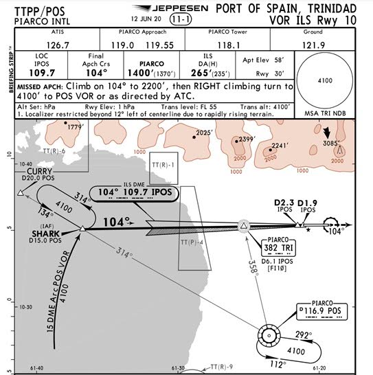
In some cases, the names correspond to notable features in the area. Two waypoints on the approach path to Piarco International Airport are named “Curry," after curry duck, and “Shark,” after bake and shark.

Comments
"Magic of air navigation"