
Why Trinidad rocks excite geologists
Geological Society of Trinidad and Tobago
Put ten geologists in the same room to examine a rock sample and you may get ten different opinions about what type of rock it is and its origin.
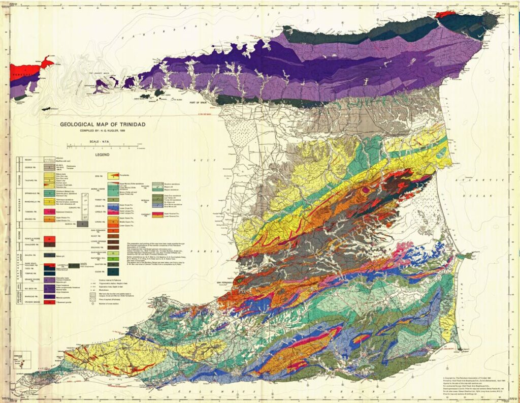
Put them in front of the 1959 surface geology map of Trinidad and there would be agreement on the geological structures, faults and stratigraphy identified. This map is the cumulation of more than 140 years of work by geologists, palaeontologists, draughtsmen and labourers and has stood the test of time.
The identification and exploitation of natural resources was the genesis of formal geological field work and mapping within the then British colony of Trinidad by Wall and Sawkins who published a comprehensive report in 1860. This included the first surface geological map, with cross sections of Trinidad, location, ages and descriptions of rocks together with the location of building materials, asphalt and springs.
The search of oil drove geologists from England to spread across most of southern Trinidad, but little was published until the government geologist, EH Cunningham-Craig, between 1904 and 1910, published maps of Trinidad oilfields that identified surface anticlines at outcrops in Point Fortin, Parrylands and Forest Reserve. Worldwide, it was being found that similar anticlines serve as traps for oil. Subsequent drilling in these areas from 1908 confirmed the presence of large oilfields.
In 1926, GA Waring published his PhD thesis on the geology of the island of Trinidad, BWI. Included was a “generalised geologic map of Trinidad” that provided additional details about the stratigraphy ie, type and age of rocks.
Also in 1926, RA Liddle published a map that identified for the first time the location of the Los Bajos fault. Lots of detailed mapping and drilling was taking place by the oil companies of the time: United British Oilfields of Trinidad, Trinidad Petroleum Development Company (TPD), and Trinidad Leaseholds Ltd; but none of the data was being published.
Hans Kugler, who is considered the father of Trinidad geology, under the auspices of the Petroleum Association of Trinidad, published a structural map of Trinidad with a tentative stratigraphic correlation table for Trinidad in 1939 for a Geological Conference.
CC Wilson, chief geologist of TPD, published in 1940, a geological sketch map of the main oil-field region of Trinidad showing the Los Bajos fault. This map identified the main faults, anticlines and synclines. Well data was critical to define these features. In 1951, HH Suter’s map of “geologic districts and major tectonic units” was the first to identify the locations of most of the mud volcanoes.
During the 1950s to early 1960s the Petroleum Association through its members, Shell Trinidad, Texaco Trinidad, Trinidad Northern Areas, Trinidad Petroleum Development Ltd, Kern Trinidad Oilfields, Dominion oil and Apex Trinidad Oilfields coordinated the publication of many papers, but most importantly oversaw the compilation of stratigraphic and structural information.
At a meeting held in Pointe-a-Pierre in 1955, the stratigraphic units of Trinidad were formalised, which allowed the standardisation of the formation names on future maps. Work from Wall and Sawkins, Cunningham-Craig, Waring, Illing, Suter, Sutton, Barr and Rohr were collated and incorporated into what became the Kugler 1959 geological map of Trinidad and geological cross sections through Trinidad at a scale of 1:10,000. At the same time, eight other maps at a 1:50,000, and 32 detailed spot maps of key stratigraphic importance were also published.
Included on the maps were the location and depths of key exploration wells.
With the departure of the foreign companies from onshore Trinidad during the 1970s and 1980s, research by Trinidadian geologists became more important. The formation of the Geological Society of TT (GSTT) in 1976 provided a vehicle to present and publish their work. Though the drilling of thousands of new wells and additional palaeontological analysis, it became obvious that revisions needed to be made. In the mid-1990s, the GSTT hosted a symposium for geologists to present their work proposing changes to the geological map. In 1997, this culminated with the Saunders geological map. Few changes were made and no well data was retained. Ongoing drilling, seismic acquisition and research by MSc and PhD students from American and Canadian universities and of course UWI, continue to add new information.
The GSTT hosted a number of stratigraphic workshops between 2014 and 2017 that encouraged presentation of new data by various companies, with the aim of further updates to the map.
So what are the benefits of the geological map to the population of Trinidad?
• Faults and earthquakes – by identifying the location and type of faults, seismic risk can be evaluated, which impacts the types of houses and buildings that should be built in these areas as well as disaster planning. For example, the three main faults are El Pilar, Los Bajos and the Warm Springs-Central Range fault. El Pilar parallels the heavily populated east west corridor and activity here could impact hundreds of thousands. Los Bajos and the Central Range fault are in close proximity to the major industrial plants in Pt Lisas and La Brea.
• Predicting areas prone to landslides and earth shifting – by knowing the formation type and their predominant lithology (rock type), one can predict the occurrence of slope failure. For example, the Cipero and Lengua formations of southern Trinidad are dominated by water sensitive and highly expansive clays. Thus, building foundations, retaining walls and roads can be redesigned to minimise failure.
• Drilling for water – the presence of fairly continuous sands (aquifers) within the Erin and Morne L’Enfer Formations within the synclines allow exploitation by water wells. The outcrops of these sands are the recharge points for these aquifers and should be protected from any industrial and housing development which can pollute the water. For example, the Sum Sum sands have been so extensively quarried for use as “Red sand” in the construction industry in the Claxton Bay and Ravine Sable areas that no rainwater can recharge the aquifer, with dramatically lower water production and quality.
• Finding limestone for cement – accurate mapping of surface geology allows limestone deposits to be identified, which is used for road construction and cement production.
• Construction – identifying clay rich formations used for production of blocks for building.
• Finally, but likely the most significant use of the geological map – oil and gas exploration. Between the locations of key exploration wells, faults, outcrops, locations of anticlines and synclines, the Kugler map continues to be a key tool in drilling exploration or development wells onshore Trinidad.
Comments
"Why Trinidad rocks excite geologists"