
Main ridge – Giving life to Tobago’s watersheds
Located in the heart of Tobago, the Main Ridge Forest Reserve encompasses 4,000 hectares of tropical rainforest, reaching heights of 604 metres.
Since 1776, it has been a crown reserve, making it the oldest protected forest reserve in the western hemisphere, home to a number of flora and fauna, including the rare white-tailed Sabrewing Hummingbird, which is endemic to the island of Tobago.
Besides having a unique biodiversity and being described as the literal backbone of Tobago, the Main Ridge also acts as a watershed, playing a vital role in our water cycle and groundwater recharge.
A watershed is a region of land where water drains into a waterbody and can exist in all shapes and sizes.
Every waterbody is a part of a watershed and will play an important role in the water cycle.
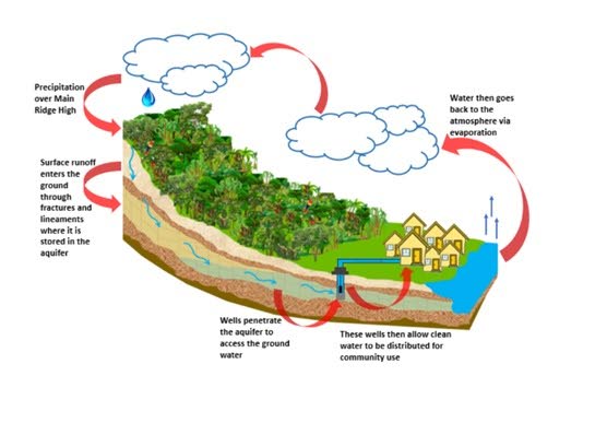
In the context of the Main Ridge of Tobago, the watershed drains rainfall from high points into surrounding streams and rivers under the influence of gravity and has an eventual location into the fifteen watersheds on the island. Some of this rainfall ends up on surfaces such as trees, rocks, buildings and other hard surfaces, while some rainfall may seep into underground reservoirs known as aquifers.
In Tobago, groundwater is produced mainly from deep-set metamorphic and igneous bedrock aquifers.
The fault and fracture systems in these rocks facilitate flow paths for groundwater.
Water wells are then used to produce the groundwater from these fractured bedrock aquifers.

A water well contains a submersible pump, which pumps water from the surrounding aquifer into the borehole of the well and then to the surface, where it is transported to a water treatment facility.
So, what makes the Main Ridge a good watershed for aquifers? The reserve consists of higher regions and then gradually becomes flatter towards the coast, giving the area a suitable angle of elevation for precipitation to run off and collect both at the surface and below.
Tobago also consists of three main lithological belts, which run roughly east to west. They are: North Coast Schist, Tobago Volcanic Group and Plutonic Suite.
All three groups are intruded by a series of dykes and are overlain by younger sedimentary rocks. The island is located along the boundary of the Caribbean and South American Plates.
Tectonic activity along these plate boundaries produces fault systems in the rocks. Linear features are formed on the surface and within the subsurface because of these fault systems and are called lineaments. It is along these lineaments that flow paths are created and feed the watersheds. Once water runoff passes through these lineaments, they flow to the aquifer.
Tobago's aquifer systems expand across the Main Ridge and are often referred to as a mega watershed. More than 90 per cent of the island's groundwater supply comes from this mega watershed.
The highly diverse nature of the aquifers is largely attributed to the varied permeability within the rock formations of the Main Ridge.
The more prevalent aquifer systems in Tobago are the bedrock aquifers containing igneous and metamorphic crystalline rock with several lineaments and fractures, while other aquifers are found within the sedimentary sand and gravel-rich formations.
Besides the changing subsurface geology, the vegetation also contributes to a healthy watershed.
The untouched vegetation within the watershed affects the quality of the water, allowing it to be free of toxic pollutants.
The Main Ridge reserve is made up of tropical rainforests, consisting of three types – lower montane rainforest, xerophytic rainforest and lowland rainforest – and a wide variety of flora such as palms, trumpet trees, Balisier, sardines, Parrot Apple, Mauba, wild cocoa, Devilwood, Blue Copper, Bowldish, Galba, Wild Manjack, Euterpe and many others known to grow within the region. Once the plants die, organic components are added to the soil. This, along with tree litter and the root systems, then protect the soil from degradation and erosion.
In addition, the forest canopy not only acts as a shelter for organisms, but also shades and regulates the impact of precipitation while keeping the water cool.
Another vital part of the Main Ridge’s water system is its transference through community use. Rainfall can be utilised domestically via harvesting systems for localised/household use, as well as agriculturally via irrigation systems for produce. However, accessibility to rainwater does not equate to usability, as the quality and quantity of the supply may not be enough for continuous dependency and usage. This can place communities at risk if their water resources are used faster than they can be replenished. Notably, the aquifer systems within the Main Ridge have been identified as the island's largest supply of water resources, providing between 20-25 per cent of Tobago's water supply.
Therefore, it is important to understand the significance of a healthy watershed, which benefits our environment, society and economy.
This article was submitted by the Geological Society of Trinidad and Tobago (GSTT).
GSTT Public Education Committee would like to extend a special thanks to Environment Tobago for providing various data maps and allowing the GSTT to assist in bringing awareness of the value of the Main Ridge Forest Reserve.
Comments
"Main ridge – Giving life to Tobago’s watersheds"