
Trinidad and Tobago in contact with countries in path of hurricane
TRINIDAD and Tobago has been in regular communication with other Caricom countries about the passage of Hurricane Tammy through the region.
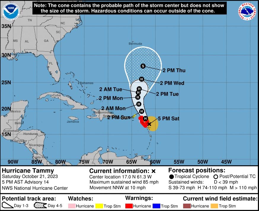
Foreign and Caricom Affairs Minister Dr Amery Browne made this disclosure on Saturday as Tammy charted a course towards the Leeward and Windward Islands.
A statement issued by the National Hurricane Centre (NHC) in Miami at 11 am, said hurricane and tropical storm conditions were expected in parts of the Leeward and northern Windward Islands were expected through Sunday as a result of Tammy's passage
Another statement issued at 5 pm, placed Tammy close to Antigua & Barbuda.
Hurricane watches are in effect for Antigua & Barbuda, Montserrat, St Kitts & Nevis, Anguilla, St Maarten/ St. Martin and St. Barthelemy.
Hurricane watches are in effect for Saba and St. Eustatius.
Tropical storm warnings are in effect for Saba and St. Eustatius.
A tropical storm watches are in effect for the British Virgin Islands
The French government has discontinued a hurricane warning for Guadeloupe, and a tropical storm watch for Martinique.
Tammy is currently a category one hurricane.
Asked about the path or potential paths that Tammy could take through the Caribbean in the coming days, Browne said, "We are closely monitoring (Tammy)."
He was thankful that Dominica seems to have escaped the storm's full fury.
"Fortunately Dominica was spared with a few showers, and both their tropical storm watch and hurricane warning have been discontinued
Browne said TT's vigilance with respect to Tammy and other potential storms that could affect the region remains sharp.
"I remain in regular communication with all my counterparts in the region during the passage of such hurricanes."
He added, "The Caricom secretariat provides us with regular updates from CDEMA (Caribbean Disaster Emergency Management Agency)."
The NHC said, "Tammy is moving toward the north-northwest near 10 mph (17 km/h) and this general motion is expected through Sunday."
The storm is expected to turn toward the north on Monday.
The NHC said, "On the forecast track, the centre of Tammy will move near or over portions of the Leeward Islands through early Sunday, and then move north of the northern Leeward Islands by Sunday afternoon."
In terms of storm rainfall, Tammy is expected to bring four to eight inches to the Leeward Islands (maximum of 12 inches), an additional two to four inches of rain (maximum six inches) to Martinique and Dominica and one to two inches (maximum four inches) to the British and US Virgin Islands into eastern Puerto Rico.
The NHC said, "These rains may produce isolated flash and urban flooding, along with isolated mudslides in areas of higher terrain."
The NHC also warned that swells in the ocean generated by Tammy will continue to affect portions of the Lesser Antilles during the next few days.
"These swells are likely to cause life-threatening surf and rip current conditions."
Comments
"Trinidad and Tobago in contact with countries in path of hurricane"