
UWI Seismic Research Centre: Monitoring earthquakes, volcanoes for 70 years
Dr Erouscilla Joseph
Director, UWI Seismic Research Centre
The geohazards monitored by the UWI Seismic Research Centre (UWI SRC) occur on timescales that are longer than a human lifetime. There are generations of families who have heard the same refrain from scientists at the centre: “Our region can experience large, damaging earthquakes and we must be prepared at all levels of society.”
The numbers do not lie, as we have had large-magnitude earthquakes, but not in our lifetimes. Add in the climate-change debate and the fatalistic approach most adults have to earthquakes, and the centre has an uphill battle to remain present within the population’s mindset.
For seven decades, the UWI SRC has ensured that the seismic and volcanic monitoring of the nine English-speaking territories it oversees is of the highest standard and quality, despite the centre’s financial challenges. We have developed partnerships with disaster management offices and stakeholders (public and private) to raise awareness of these hazards.
Through funding via projects with international agencies and partners, we have maintained a presence on each territory. With the need to maintain the global standard for monitoring agencies like ourselves, we are constantly developing to ensure adequate monitoring services are provided and that our messages are understood and, more importantly, implemented.
Earthquakes greater than magnitude 3.5 are reported in real time to our interactive map on the website (www.uwiseismic.com). After an earthquake, in the space of minutes, an automatic solution is posted to our social media platforms.
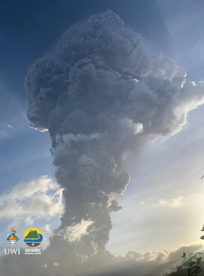
We share the latest research and updates on monitoring techniques and simplify scientific terms to help the public better understand the geohazards that we monitor. The staff at the centre can be mobilised in hours to respond to signs of increased volcanic unrest on any of the islands that we monitor and our recent management of the La Soufriere 2020-2021 eruption in St Vincent and the Grenadines was not just successful (no fatalities recorded), but earned a most prestigious award from the global volcanology community.
The research we undertake often has tangible products that can be implemented into a country’s mitigation or planning framework.
One such endeavour, the TT Microzonation Project (TTMP), was a collaboration between the Ministry of Planning and Development (MPD) and the centre that began in 2012 and ended in 2021.
The project developed seismic microzonation maps for ten towns and cities throughout TT. In order to better define the seismic hazard in urban areas, the project involved extensive geological and geophysical fieldwork and collection of data.
The products are thematic maps, which can be used by city planners to better develop urban areas and help them minimise earthquake impacts. We often state, "Earthquakes don’t kill people, buildings do," and we continue to raise awareness in this regard.
Understanding the hazard can help reduce risk and we firmly believe that the younger generation is key to changing behaviours and adopting a more proactive mindset. The Education and Outreach section at SRC conducts hazard science and safety sessions from pre-school up to tertiary levels, and often trials new and interactive techniques to attract the attention of all stakeholders.
The SRC has developed a suite of animations that explains tectonics in the region, volcano monitoring and geothermal exploration. Our state-of-the-art website is an important tool for students, engineers, scientists, and the public.
Our engagement with the public on our social media platforms helps to dispel rumours and myths and create a community of citizen scientists. Our "Did you feel it?" campaign aims to encourage people to fill out forms after an earthquake, a necessary input for the creation of intensity maps for that event.
We hope to continue to build a community not just online, but on each island, that contribute valuable observations to improve our understanding of seismic activity in the region.
We acknowledge that the hazards we monitor can be frightening and have the potential to devastate our societies, but we hold firm to the conviction that the work done by the SRC and the dedication of its staff can help provide our communities with a proactive, positive mindset that can help reduce the loss of life and property when the inevitable occurs.
The funding received from our contributing territories in the Eastern Caribbean continues to be inconsistent and supports only the operation of a minimal seismic network. This situation should not be considered lightly, and we strongly encourage governments to demonstrate their commitment to disaster-risk reduction in the region through their support of the operations of the centre.
UWI ON THE GROUND
A university must be centred in the community, leading on the key issues of the day. Accordingly, UWI St Augustine offers this public service series, where its leading scientists and researchers will address climate and disaster challenges – Series 1.
This week Dr Erouscilla Joseph, director of the Seismic Research Centre, discusses how we can be part of the movement to monitor earthquakes.
Prof Rose-Marie Belle Antoine
Principal, UWI, St Augustine
Comments
"UWI Seismic Research Centre: Monitoring earthquakes, volcanoes for 70 years"