
Grande Riviere beach shifting: Coastline requires coastal zone planning
Christopher Alexis and Isabelle Chen
Oceanography and Coastal Processes Department
IMA
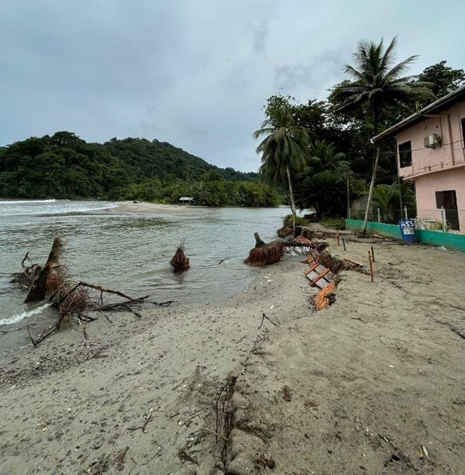
Grande Riviere Beach, on the scenic north coast of Trinidad, gets its name from the large river that empties into the Caribbean Sea at the eastern end of the beach. It spans approximately 1.2 km in length and is curved with varying beach widths (Photo1).
This beach provides an important habitat for marine and coastal wildlife. It is one of the most important nesting sites for the leatherback turtle (
Dermochelys coriacea), which has been declared vulnerable on a global scale by the International Union for Conservation of Nature (IUCN) Red List and World Wildlife Fund (WWF), and nationally as an environmentally sensitive species.
Grande Riviere beach provides a landing site for fishing vessels and the surrounding forest provides great bird-watching opportunities, being home to such species as the endangered blue-throated piping-guan (pawi).
According to the Grande Riviere Nature and Tour Guide Association (GRNTGA) and the Turtle Village Trust (TVT), the main income generating activity in Grande Riviere is eco-tourism, as each year an estimated 15,000 tourists, both foreign and local, visit this community.
Beaches provide protection from coastal processes (waves, currents, tides) and are in constant flux of erosion and accretion. To the average beachgoer, each beach may appear with time narrower or wider, steeper or gentler in slope, or the same all the time.
Beach erosion can have significant impacts on coastal infrastructure such as jetties, commercial property such as hotels and guest houses, and residential properties, and therefore affects the lives and livelihoods of individuals, communities and on the country as a whole. For these reasons, the need arises for coastal-zone planning and management. These measures are needed if we want to continue to enjoy our beaches.
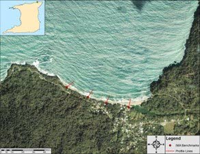
In recent times – 2002, 2012 and last year, 2022 – meteorological phenomena created conditions that resulted in changes to the course of the Grande Riviere River and movement of sand along the beach. In October 2022, it was observed that the course of the Grande Riviere River had been shifting westward. This shifting and widening of the river mouth led to the removal of sediment (sand) from the berm, and the easterly and westerly sections of the beach were completely separated by the wide river mouth (Image 2). The large volume of sand removed resulted in damage to coastal infrastructure and affected the local economy and posed a threat to the turtle-nesting season in March 2023.
While these changes, described as mass erosion events, may seem drastic, it is understood that this is a natural process of sediment cycling along the shoreline. With time, the sand would naturally be replenished, unless the sediment is washed too far offshore by extreme turbulent sea conditions.
The westerly end of the beach is in a state of dynamic equilibrium, where there is no net loss of sand, and the backshore area is stable thanks to the resistant cliffs, characteristic of the North Coast. The eastern section of the beach, especially the berm close to the mouth of the Grande Riviere River, is dynamic and experiences frequent changes in sediment elevation. Beach accretion is usually between May and October, where sand accumulates on the beach when wave energy is low. Conversely, sediment is eroded and carried offshore between the months of November-March when wave energy is high.
The winter swells experienced during the months of December through February superimpose higher energy, creating larger waves that reach up to two metres and allow the offshore sediment to be returned onto the beach. This is the natural sediment cycling process. The hydrology of the river also influences beach erosion. During the rainy season, with increased precipitation, river discharge is increased, leading to increased volumes of water and increased velocity, which cause the river to erode and transport more sediment from the beach into the offshore area.
In recent years, with more frequent extreme rainfall, the river mouth has been known to widen or change course, which leads to larger sections of the beach being eroded.
The Institute of Marine Affairs (IMA) has been monitoring this beach for over 20 years, has investigated past events in which extensive volumes of sediment were removed from the beach and carried offshore, and has observed that the offshore sediment returned to the beach over time (weeks to months). The exact timeframe for replenishment is uncertain, as it relies on marine and meteorological conditions.
With the impacts of climate change such as more frequent and intense storm events, and sea-level rise, engineering solutions will be considered to mitigate erosion. Traditional hard engineering coastline-protection measures such as constructing sea walls, or redirecting rivers, such as the Grande Riviere, need to be closely evaluated, as Grande Riviere is an ecologically sensitive area.

In 2012, the Drainage Division (Ministry of Works and Transport) constructed a sand dam for the diversion of the river channel. Heavy machinery removed sand from the western side of the bay and translocated it to the eastern end of the bay, where the river caused extensive erosion. This moving of the sand led to the destruction of turtle nests, eggs and hatchlings. The unfortunate scenario highlighted the need for caution in such work, especially in ecologically sensitive areas.
Decision on interventions should be based on scientific data with respect to the coastal dynamics at Grande Riviere Beach. Taking into consideration the ecological importance of the area, as well as knowledge of the natural sediment cycling that accounted for past erosion events, a "no-action" plan should be adopted, in which the sediment would be allowed to return naturally, and any potential damage to the natural environment would be reduced. Recalling similar events that were witnessed in Grande Riviere in 2002 and 2012, coupled with the historical IMA dataset, natural recovery allowed the beach to revert to its previous condition in a few months.
This underscores the importance for proper coastal-zone planning. It is important to identify and delineate coastal areas into land and sea-use zones with identified permitted and prohibited conditional uses. This can aid in planning and management of the coastline and adjacent areas and can reduce coastal vulnerability associated with changing weather patterns, coastal erosion and sea-level rise.
Grande Riviere, a high-energy beach, is constantly changing and subject to oceanographic and meteorological forcing factors. Owing to the ecologically sensitive nature of the area, it is not recommended that hard engineering structures or beach nourishment be used to curb the coastal erosion taking place, as anthropogenic interference can have negative consequences to this key environmental site. The natural sediment flux of the beach has shown in the past that the sand will naturally be replenished over time with the ambient conditions. Proper coastal-zone management and planning need to be implemented in the area so new infrastructure will not be threatened by the imminent erosion of sediment.
Information dissemination about the significance of sustainable coastal-zone planning is of utmost importance for areas such as Grande Riviere and by extension the entire coastline of Trinidad and Tobago.
Comments
"Grande Riviere beach shifting: Coastline requires coastal zone planning"