
Mysteries that lie beneath the rubble: analysis of Piparo mud volcano
AARON MUNGAL
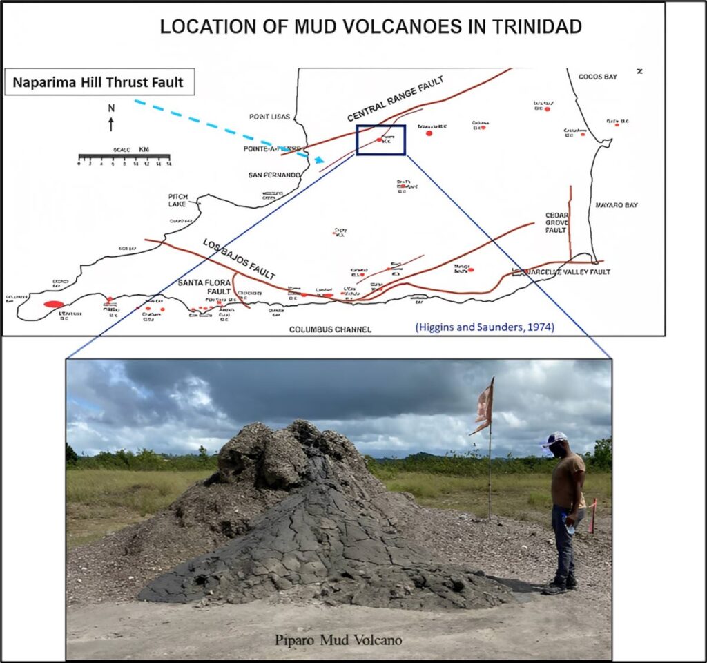
In the Southern Basin in Trinidad, there are many mud volcanoes that litter the landscape.
"Mud volcano" is a misnomer, as it is not a conventional volcano that spews molten lava.
These are natural onshore and offshore surface expulsions of semi-liquid mud and gas.
One such example of a mud volcano is the Piparo mud volcano.
To many, the Piparo mud volcano is a exciting tourist attraction, to others a spiritual site and to a remaining few, a part of what they called home.
A major eruption on February 22, 1997 transformed a small muddy pool into the large main vent we see today (Figure 1) and resulted in damage to homes, leaving many homeless.
From that day forward, continuous activity at the site has led to many studies and frequent surveillance being carried out by UWI and other organisations.
(Figure courtesy GSTT) -
ERT (electrical resistivity tomography) and DEM (digital elevation models), for example, are methods that were used to uncover the origin of the fluid, processes and activity of the mud volcano. The information received from this surveillance can be used to predict future eruptions and help warn nearby residents.
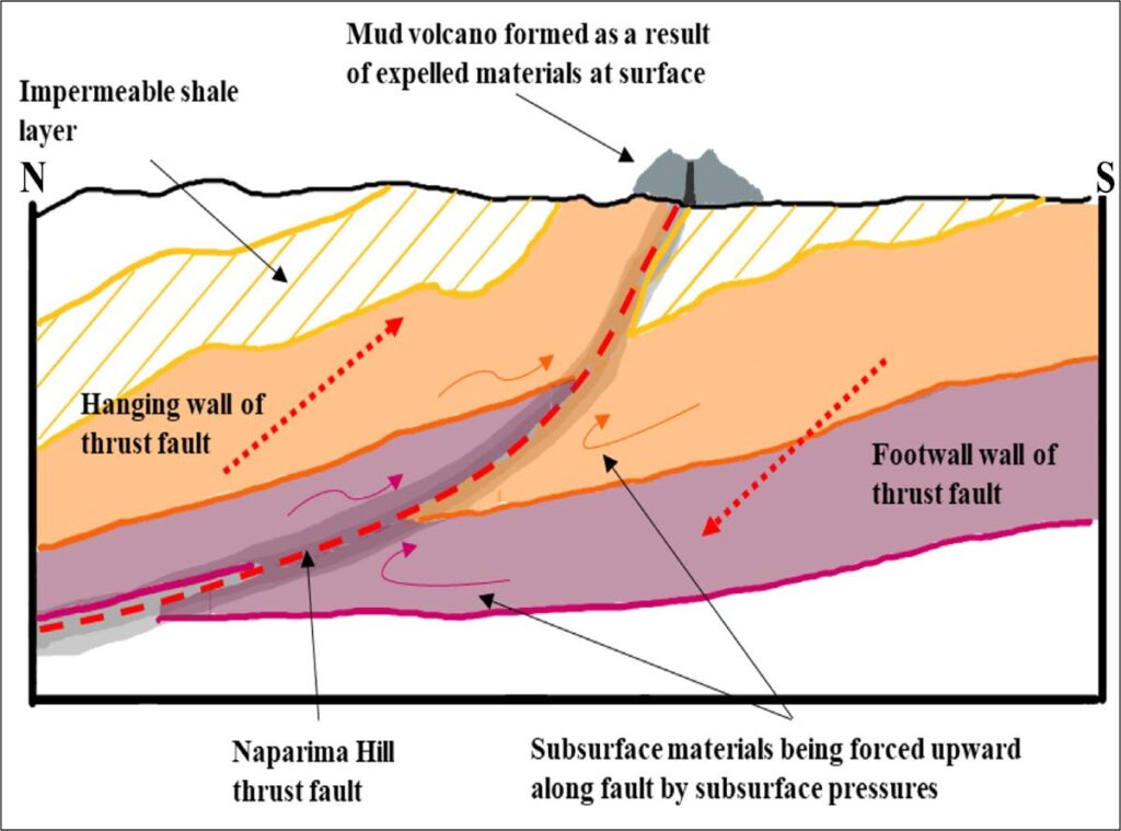
The mud volcano lies along the Naparima Hill thrust fault, along which mud is transported from great depth to the surface. This fault was formed by transpression that occurred between the Caribbean and South American plate around the mid-Miocene (around 12 million years ago).
This opened up a gateway for materials that were even older than this compressional event to be transported to the surface and seen at the site of the volcano today (Figure 2).
Although many are able to see the expulsion of mud at the surface, the subsurface expression of the volcano remains hidden.
ERT surveys can map out an image of the subsurface by measuring its resistivity or its ability to resist an electric current.
Different objects will carry different resistivities, allowing us to create a colour-coded image with the data that is collected. From this image we can identify any resistive objects.
DEM surveys on the other hand, work by using drone captured aerial images to create colour-coded elevation maps. These maps can be used to identify any topographical or surface changes over time.

(Figure courtesy GSTT) -
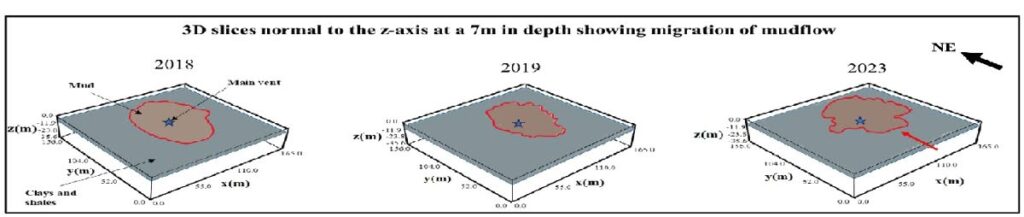
For this study, datasets from the years 2018-2023 were used to track changes in the subsurface shape and topographic elevation through time.
The datasets have given insights into the nature of the mud volcano. It ejects mobile mud (clays and shales mixed with fresh water) (Figure 3) which eventually hardens when dried, creating a mound with the resistive values of the subsurface being indicative of this. The subsurface chamber of the mud volcano had an approximate volume of 176,493 cubic metres in January of 2023. For reference, that volume is equal to approximately 1.1 million oil barrels!
This volume was limited by the resolution of the resistivity survey (36m depth) and there could indeed be much more beneath the surface.
This body of mud was also seen to be migrating or moving in a general easterly direction between 2018 to 2023 (Figure 4), triggered by the occurrence of earthquakes during that time.
Another observation to note was the collapse of the area around the main crater between 2018 and 2019. Looking further, we saw that the entire area decreased in elevation between 2019 and 2023 (Figure 5).
How can these observations impact the residents near the Piparo mud volcano?
If this body of mud continues to migrate in an easterly direction soon it will interact with infrastructure in that direction.
(Figure courtesy GSTT) -
In addition, as the mud continues to migrate away from the volcano’s main vent seen at surface, current interpretations suspect it will initiate the formation of a new main vent owing to the build-up of subsurface pressure as the current seepage pathway becomes too deviated to function.
To put it simply, the further the body of mud moves from the main vent, the higher the possibility of another eruption.
The impact of this needs further assessment to draw any conclusions and for now is only a possible outcome.
Further tests and surveys will provide us with vital information on the activity of the volcano, allowing us to better understand and prepare before its advancement.
However, we should always remember that many mysteries lie beneath the rubble and the more we uncover and share, the more we begin to appreciate this natural wonder.
Aaron Mungal is a petroleum geoscience graduate from UWI who did his final year project on the Piparo mud volcano. This article was submitted by the Geological Society of TT.
Comments
"Mysteries that lie beneath the rubble: analysis of Piparo mud volcano"