
Benefits of a co-ordinated Geospatial Information Strategy
Dr Bheshem Ramlal
The value of information is in its use.
In TT, public, private, and non-government organisations collect extensive amounts of digital information in every sphere of our society. Since almost everything that happens, happens somewhere, most of this information is locational or geospatial in nature.
Decision-making and policy formulation requires access to such information. Such activities rely on not only on knowing what happened, but also where it happened, and most importantly why it happened. This allows us to find solutions, develop appropriate policies, and make the best possible decisions using the best available information. The availability of very advanced tools such as artificial intelligence, deep and machine learning, big data analytics, and other such technologies makes it even easier to support such efforts.
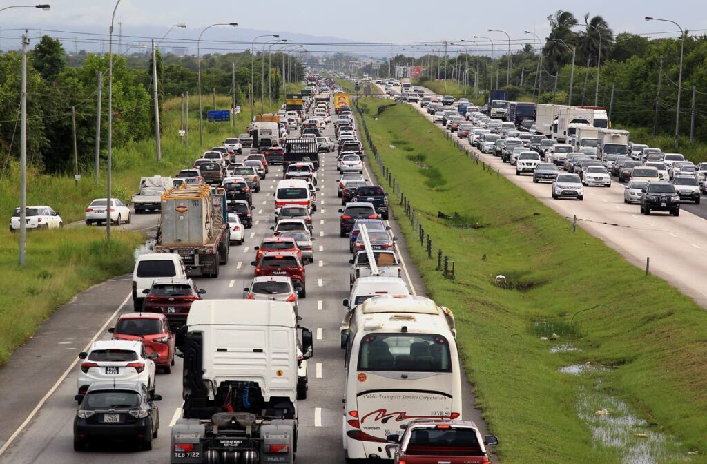
Locally, we are plagued with extensive challenges that are likely to be further exacerbated with reduced access to resources and climate change. Flooding, crime, traffic jams, and poor road conditions are but a few of the many issues experienced by many in our society. Understanding the problem is the first step in finding a solution. A clear appreciation of the issues would require access to the right information at the right time. Only then, can we attempt to develop the appropriate measures to eradicate or mitigate the challenges at hand. Most public agencies are mandated to collect data appropriate to the needs of their operations. Many of these organisations choose not to share their data with other organisations, preferring to operate in silos. The lack of access, whether from a lack of appreciation of the benefits of sharing, unwillingness, or inability to share data with other organisations, frustrates the decision-making and policy formulation process.

We are all familiar with the extensive flooding that is repeated every wet season, for example. Our first impression is that this is an issue only for the disaster-response agencies to deal with. However, we need to understand the causes and the impacts of flooding before we can propose solutions.
In terms of what are the causes of floods, we need to (i) appreciate the distribution and levels of rainfall occurring over the islands and the potential impacts of climate change, (ii) collect data on stream flows, (iii) determine the capacity of rivers, (iv) determine the changes in land use and land cover including forest cover for all of our catchment basins, (v) identify the soil types and terrain variations, (vi) locate existing infrastructure such as roads, bridges, culverts, and retention ponds. Without access to the required information from diverse agencies, it is unlikely that we can arrive at workable mitigation and management strategies such as adding retention dams, improving drainage systems, or installing early warning systems in areas of priority.
Similarly, the impacts of flooding are destructive and far reaching. It is not only private homes that are affected. Agricultural areas are often destroyed, which directly impact the livelihoods of farmers and leads to significant shortages of food and price increases. The loss of infrastructure is not uncommon. At least ten agencies and ministries need to respond to these impacts and to collect and collate the data on the social, economic, and other impacts of floods to provide a holistic picture of the human and financial costs to society. Knowing what the causes of the problem are and appreciating the real impacts, would allow more in-depth analysis of whether we need to introduce measures to mitigate the problem or if we can afford to continue without further intervention.
Notwithstanding the final decision, we believe it is important to have a whole of government approach, which must include all agencies and ministries, to national problem solving. The Department of Geomatics Engineering and Land Management is working with other colleagues from the UWI, to conduct extensive research that includes utilising geospatial tools and technologies for planning and development, crime management, disaster mitigation and management, and agricultural development.
We are also working with several public agencies in improving their operations. The challenge of working in silos reduces the return on investments of these efforts. It may be useful to set up a co-ordinating agency to facilitate better collaboration and co-operation, such as the National Spatial Data Infrastructure Council proposed by the UWI since 2013. We believe that additional benefits will be realised using this approach, including significant reduction in duplication of efforts and resources, cost and time savings, and the ability to leverage the best human talents across agencies to provide the technical expertise in improving the quality of life for all citizens.
UWI ON THE GROUND
A university must be centred in the community, leading on the key issues of the day. Accordingly, the University of the West Indies, (UWI) St Augustine, offers this public service series, where its leading scientists and researchers will address climate and disaster challenges – Series 1. This week Dr Bheshem Ramlal, senior lecturer in Geoinformatics, Cartography and Geomatics Engineering, alerts us to the importance of an adequate, modern, data infrastructure if we are to appropriately address disasters.
Prof Rose-Marie Belle Antoine
Principal, UWI, St Augustine
Comments
"Benefits of a co-ordinated Geospatial Information Strategy"