
The plates that trigger earthquakes
Varendra Saith
On February 6, 2023, at approximately 4.17 am, central Turkey and northern Syria were rocked by a magnitude 7.8 earthquake, centered around Turkey's Pazarcik district in the Kahramanmaras province. Amongst the strongest quakes to hit the region, the natural disaster has already been estimated to claim over 51,100 lives (as of February 28).
Since the main shock, Turkey has also experienced over 100-plus aftershocks, the strongest being a 7.6 tremor nine hours after the main quake. Fifteen days later, a 6.4 earthquake occurred, with its epicentre in Turkey’s Hatay Province. Scientists estimate that these aftershocks could continue for months after the main event, further compounding the damage done to the region.
Why did such a disaster occur? The answer lies in plate tectonics.
Tectonic plates are enormous slabs of the Earth's crust that float on top of the Earth's Mantle. They are able to move due to a number of mechanisms, such as lateral density variations and differences in mechanical strength between the lithosphere and athenosphere, which are different layers of the Earth.
Turkey is located on the intersection of three tectonic plates: the Anatolian, the Arabian and the African plates. The Arabian plate is currently moving northwards, which causes the Anatolian plate (which Turkey sits on) to rotate counter-clockwise and move westwards, as it is being impeded from moving northwards by the Eurasian Plate.

This creates a couple key geological features, most notably the East Anatolian Transform Fault, a left lateral strike slip fault system and the North Anatolian Fault system, a right lateral strike slip fault system. The interaction of these plates creates an active seismic zone, with the Anatolian transform fault system estimated to be the most active system in the world, with over 70 earthquakes of 6.5 or higher since 1900.
As the Anatolian plate slides past the Arabian Plate, stresses build up on the fault zone. At some point, the stresses would overcome the friction holding it back, resulting in a sudden movement, which causes earthquakes. The February 6 disaster is likely to have occurred along the East Anatolian Fault zone, evident by the aftershocks having their epicentres within the fault zone itself.
Now, why is this significant for TT?
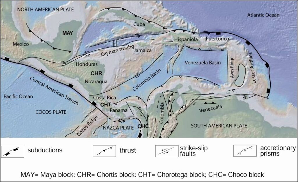
Like Turkey, Trinidad resides on the boundary between the Caribbean Plate and the South American Plate. This plate margin is currently active, where the Caribbean Plate is currently moving eastward past the South American Plate at a rate of 22 mm per year (Pérez, O.J. et al. (2001).
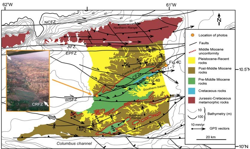
Similar to the East Anatolian Fault Zone, the southern boundary of the Caribbean-South American plate interaction is a transform zone, with elements of subduction and thrusting present. The Caribbean - South American Plate Boundary actually bisects the island of Trinidad, where the El Pilar Fault Zone and the Central Range Fault Zone are major components of this boundary.
Does this now mean that Trinidad is at risk for a massive earthquake? In general terms, yes. According to studies done by the United States Geological Survey (USGS), the stresses that have built up along the Central Range Fault Zone can unleash massive earthquakes in excess of M 7.0.
In fact, in recent times, we have experienced several large earthquakes, with the most significant occurrence being a 6.9 shock on August 18, 2018. The quake had its epicentre in Venezuela, but had significant effects on TT, such as damage to property and infrastructure, and loss of essential utility services across the island.
Seismologists have estimated that, had the epicenter been closer, it'd likely that we'd see far greater damages that what was experienced. Dr Illias Papadopoulos, engineering seismologist at the Seismic Research Centre at the University of the West Indies has indicated that soil liquefaction is a significant consequence of future potential earthquakes.
Soil liquefaction occurs when the water saturation in soil sediments is high, resulting in a reduction in the stiffness and strength of the material during events such as earthquakes. This could result in structures sinking into the soil upon which they were built. A classic example would be the structures after the 1964 7.5 earthquake in Niigata, Japan, where entire multi-storey buildings became tilted or were completely overturned, as they were built on loosely packed sub-soil deposits. According to Dr Papadopoulos, this poses an extreme threat in areas such as reclaimed land zones in the capital city of Port of Spain, as well as significant areas in southern Trinidad, where the sediments are unconsolidated and soft.
We should be prepared for a big earthquake, regardless of whenever it happens. Dr Joan Latchman, former director of the Seismic Research Centre, has spoken about the increase in seismic activity in the region, and called for development and updates to policy to ensure that structures adhere to earthquake building codes. Most structures, especially residential buildings, are not built nor designed with earthquake mitigation in mind and therefore pose significant risk of structural damage, collapse, and threat to life during such an event. After-effects of an earthquake, such as landslips and fissures. often cause more damage and could effectively cut off vital transportation routes to more remote areas, hampering rescue efforts even further. Dr Latchman has also called for a plan for mitigation and relief measures in the case that such a natural disaster strikes our small twin island republic.
Varendra Saith is a staff geophysicist at the Ministry of Energy and Energy Industries, with experience in exploration and management in both onshore and offshore environments. He has a bachelor's in petroleum geoscience from the University of the West Indies and is a member of the Society of Exploration Geophysicists. Follow the Geological Society of TT on Facebook, Instagram, LinkedIn and check out https://thegstt.org/
Comments
"The plates that trigger earthquakes"