
A wetter dry season
What does a wet dry season really mean? Dr Anjani Ganase explains the phenomena that originate in the Pacific Ocean, El Niño (the child) and La Niña (the reversal).
Humankind’s path has always been at the mercy of the weather, climate, oceans, and atmosphere. Those capable of understanding the environment were able to use the winds to sail to foreign lands or to successfully grow crops with higher yield and survive disaster. Today, we have the best tools and capacity to monitor and observe our planet and mitigate for environmental shifts, but no matter how much we’ve learned, we will always be at the mercy of the planet.
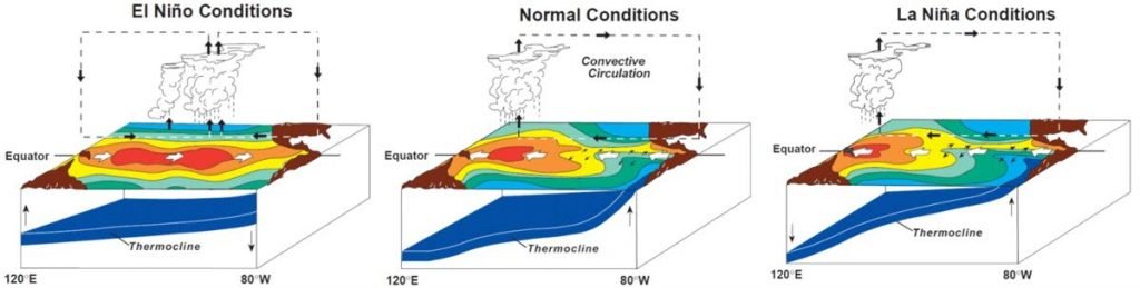
The might of the Pacific Ocean and its oceanic circulation can be felt in weather patterns around the world, a continent away. This is because of the strong connectivity between oceanic circulation and atmospheric conditions. The El Niño Southern Oscillation (ENSO) is one example of a large-scale dynamism, where the tropical oceanic circulation in the Pacific influences the weather patterns in the Indian Ocean and even the Atlantic Ocean. Under normal or neutral circulations in the Pacific, the easterly trade winds blow the warm, surface waters of the tropical Pacific west away from the Americas towards the Indo-Pacific. This facilitates the upwelling of deep nutrient rich water off the coast of South America. This upwelling provides nutrients for the plankton in the waters and forms the base of the food web of several coastal and offshore marine ecosystems in the area. The intensity of the oscillation can vary and result in the famous El Niño and La Niña events.
El Niño southern oscillation occurs where the easterly trade winds weaken, and the warm surface waters are not pushed west. Rather the warm waters remain off the South American west coast, creating a thermocline, where the warm surface layer of the water floats above the colder water below, creating a barrier that prevents the access to nutrients in the cold layer. In the absence of these upwelling waters, marine communities that include an array of fish populations, marine mammals and sea birds suffer from food deprivation that may result in die off events. This in turn impacts the countries that depend on the marine resources. The body of warm water also alters the weather conditions in the immediate surroundings which have rippling consequences in other regions of the world. The El Niño phenomenon can occur every three to five years and can last between nine and 12 months.
The name El Niño has been tracked since the 1600s, when the fisherfolk refer to it as the El Niño or the Christ child, since the events tend to happen around Christmas time. Today, the ENSO has been linked to impacts on the weather conditions all over the world as scientists recognise the inter-connectivity of oceanic and atmospheric conditions. El Niño often results in distinct regional weather patterns. During an El Niño event, drought conditions are expected in the western Pacific, such as Australia and Indonesia. In the USA, the southern states tend to have wetter than usual winters, while the northern states experience milder and drier winter conditions. In the Caribbean, El Niño tends to drive calmer conditions and a milder hurricane season.
This year, we have been feeling the effects of a moderate to strong La Niña event, which is essentially the reverse to El Niño. The easterly trade winds strengthen along the Pacific equator resulting in higher than usual upwelling events along the South American west coast. The additional nutrients boost the local marine populations. For weather patterns farther afield, it results in very cold winters in the northern USA and drier conditions in the southern states. A La Niña event can also drive a more active hurricane season as was seen last year. La Niña, which started in 2020, was expected to peak in January and February 2021 but impacts are lingering to May, resulting in a wetter than usual dry season.
The history of El Niño/La Niña phenomena has been linked to notable events around the world dating back to pre-historic times. Scientists have been able to track patterns of El Niño stored in chemical records, such as in coral cores. They have been able to date ENSO events all the way back to the last Ice Age. It is theorised that the crop failures in Europe in 1876 and which drove the French revolution may have been related to El Niño. Other crop failures in the 19th century led to one of the biggest famine events that occurred around the world including China, India and Brazil and resulted in the deaths of 30 to 60 million people. As our knowledge of the ENSO grows, scientists have been able to link the ENSO phenomenon to mass fish kills along the South American coast and the crash of the anchovy fisheries in 1972/3 resulting in political unrest and food insecurity. They have also linked it to kelp forest loss in California. In 1982 – 1983, sea lions and seals starved to death and sea birds abandoned their young to fly as far out as they could to find food.
During the 20th century, we have become good at observing the ENSO events. Scientists have a special interest in the influence of global warming on the ENSO events. In 1998, the ENSO, piggy backing on an already warming ocean, resulted in global mass bleaching of coral reefs around the world. This was the first of many mass bleaching events observed in the following 20 years. Today mass coral bleaching events no longer require an El Niño scenario to cause devastation. However, scientists still do not know how climate change will influence the ENSO. There is the potential for an enhanced effect where the warmer conditions are exacerbated during an ENSO or that the ENSOs themselves will get stronger. Scientists who have tracked 70 El Nino events in the last century have shown an increase in the frequency and strength of the El Niño event since the 1970s. Additionally, scientists are learning that each El Niño event may be unique because of many different ecological impacts, including the deaths off of sea birds and marine life in one area, and the next time, in another area, while bringing rainfall to areas of drought in other locations.
Future scenarios of El Niño and climate change are still being investigated but the likely predictions are more severe weather events, such as higher probability of wildfire in North America. The other theory is that ENSO events in the future may change altogether in response to the shifting oceanic circulation patterns driven by climate change. Considering the significance to agriculture and fisheries which are the lifelines of human populations, it is important that we continue to learn and understand as much as possible about our oceans and atmosphere and learn to adapt as we have done for the entire history of humankind.
Comments
"A wetter dry season"