
Tropical Storm Gonzalo to pass north of TT

THE MET Office has forecast that Tropical Storm Gonzalo will pass just north of TT on Saturday.
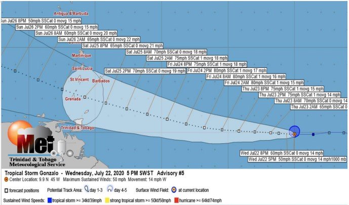
In an advisory on Wednesday it reported that Tropical Depression Seven had developed into Tropical Storm Gonzalo.
"Current analyses suggest that on its current track, the centre of the system is forecast to reach the Southern Windward islands by Saturday morning and is expected to move just north of TT."
The Met Office said Gonzalo was about 1,785 km east of the Southern Windward Islands and is moving toward the west near 22 km/h.
"A general westward motion at a faster forward speed is expected during the next few days. On the forecast track, the centre of Gonzalo would approach the Windward Islands late Friday into Saturday."
Maximum sustained winds were near 85 km/h with higher gusts.
"Strengthening is forecast during the next couple of days, and Gonzalo is expected to become a hurricane by Thursday."
The Met Office explained that Gonzalo is a small tropical cyclone, as tropical-storm-force winds extend outward up to 55 km from the centre.
It said people should pay close attention to the information being issued by visiting www.metoffice.gov.tt.
Comments
"Tropical Storm Gonzalo to pass north of TT"