
Urban planning and mass transit

Look at a map or aerial imagery of a community. Focus on a public transportation stop; be it a bus or train stop, or a major transit station or hub. Imagine that this transportation node is at the centre of a circle.
The area of the circle is called a pedestrian shed. The circle depicting the area covered in a five-minute walk from a central point — roughly a quarter-mile radius — represents an important metric.
Planners have determined that most people will walk for five minutes to reach a typical public transportation stop. For more major stations or express service stops, many people will walk for ten minutes — sometimes longer — or a half-mile.
This shed, or area of influence, around a transportation node is of utmost importance when looking at the intersection between land use and transportation planning. From the perspective of population density — the number of residents within a given area of land — allowing for more intense use of land within the pedestrian shed of a transit node is critical in the move towards a more pedestrian and public transit-driven transportation system.
The intensity of land use within the shed — in order to maximise usage of public transit — is determined almost exclusively by land use or zoning regulations.
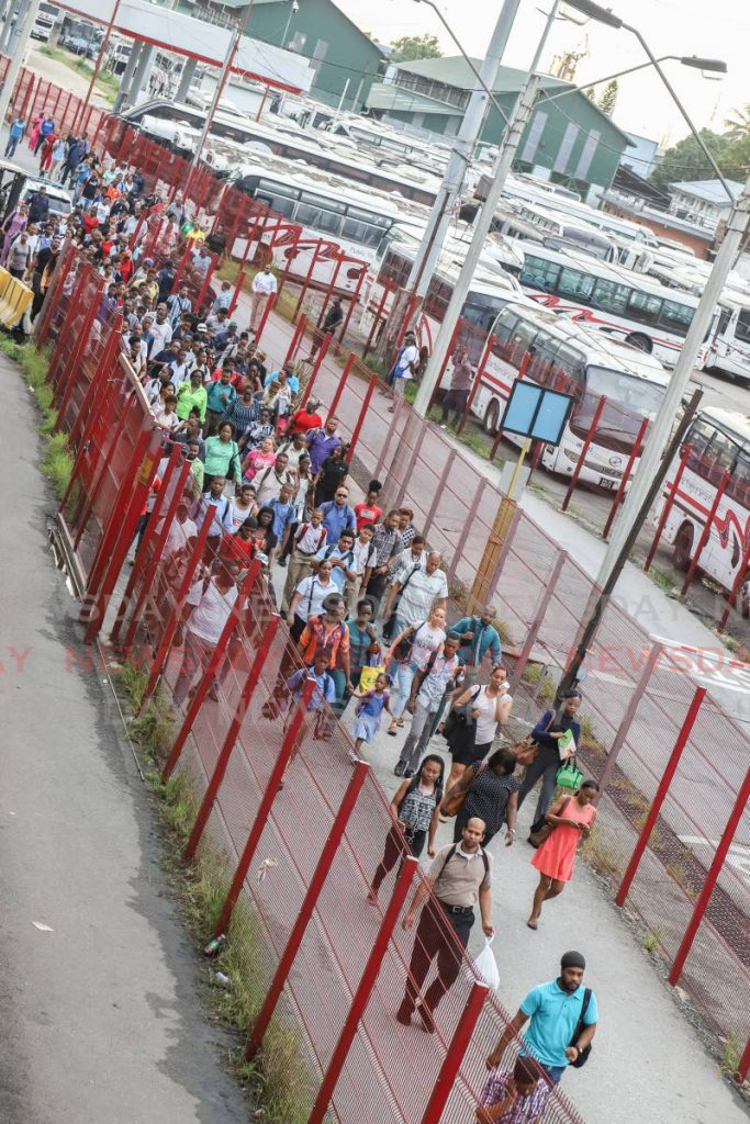
Consider the Priority Bus Route. This heavily used public transportation route provides a great opportunity to further reduce automobile ownership and usage along the East-West (EW) corridor.
If we are ever going to move away from our addiction to imported cars, getting more people to live within the pedestrian shed of transit nodes, with lowered or no parking requirements for multifamily housing developments, must be high on the agenda.
Our current zoning methodology is mostly based on a main street approach. When a lot is located on a main thoroughfare, the allowed intensity of land use is typically higher. This represents a missed opportunity to use land that may be on a minor roadway, but still located within the pedestrian shed, more efficiently to create a more environmentally sustainable and economically efficient transportation system.
No doubt many remember the plan to build a rapid rail system along the western (Diego Martin to PoS), EW, and north-south (NS) corridors. How many have stopped to wonder how land use patterns affected the economic feasibility of that system?
Even along the EW corridor, where land is used far more intensely than on the NS corridor, the rapid rail was not feasible. There were simply not enough potential riders within the sheds of the proposed stops to justify the capital and operational expenses.
How intensely we use land (population density) is related to our chosen modes of transportation. Unbeknownst to many urban planners—including myself at one point in time—we have relatively high rates of usage of public transportation.
Data from 2008 tells us that along the western, EW, and NS corridors, public transportation made up 22 per cent, 48 per cent, and eight per cent of trips. Consider that in 2009 a study by National Geographic found that only seven per cent of Americans reported weekly use of public transportation.
Yes, we are now in 2019 and our rates have likely changed, but to assume that overall local rates have plummeted to American levels would probably be misleading. Weaning ourselves off of the automobile is not as far-fetched as we believe it to be.
Land use planners are trying to avert the apocalypse by waiting for the public transportation system to improve before seriously reassessing residential density allowances and minimum parking requirements. Reality is unfortunately not like a theoretical textbook scenario. Step B does not always follow step A; sometimes it has to occur before or simultaneously.
- JEFF K MAYERS
Places with all levels of public transportation systems that have taken steps to reduce minimum parking requirements, for instance, have miraculously escaped a fiery fate.
Investment in mass transit, particularly along the NS corridor, is simultaneously being stymied because of the short to medium — and possibly long — term economic inefficiencies of such a system.
It is a classic case of the chicken and the egg. What comes first, the transportation system or the population density to support the system?
In some places, a mass transit system is built and then the land uses around it, in the absence of restrictive zoning, respond accordingly with high-density pedestrian sheds forming. This is already happening in the petrochemical driven economies of low-density, sprawling Dallas and Houston, Texas.
In other cases though — and maybe where we fit in—the planners need to actually make a decision to initiate the process, by utilising zoning as a tool to first build the required density, with the transit systems eventually being implemented in response to it.
We are certainly in the midst of a crisis in judgement when the regulatory agency stipulates the same rate of parking provision for a development located directly adjacent to City Gate — for affordable housing no less — as one located in the suburbs far from any hint of a bus or maxi taxi.
Ryan Darmanie is a professional urban planning and design consultant, and an avid observer of people, their habitat, and the resulting socio-economic and political dynamics. You can connect with him at darmanieplanningdesign.com or email him at ryan@darmanieplanningdesign.com
Comments
"Urban planning and mass transit"