
Barbados braces for Tropical Storm Dorian
BARBADOS is bracing for the impact on Monday of Tropical Storm Dorian which, on Saturday, was upgraded from from a tropical depression by the National Hurricane Centre in Miami. Other areas of the Eastern Caribbean especially St Lucia are expected to feel the effects of Dorian on Tuesday.
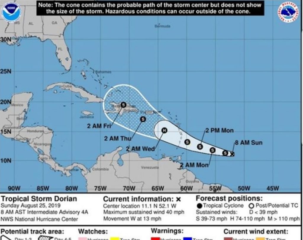
The TT Met Office said the storm is heading towards Barbados by moving north-west-north from an Atlantic location east-south-east of the island.
“This system is forecast to gradually strengthen and can be near hurricane strength by the time it approaches the Lesser Antilles sometime on Tuesday.”
On the current forecast track, TS Dorian poses no direct threat to TT or Grenada, the TT Met Office added.
“Numerical prediction models have tropical storm Dorian affecting the islands of the northern Windwards and southern Leewards sometime on Tuesday.” The Met Office urged the public to follow updates on its website or on social media.
The National Hurricane Centre said yesterday the storm is 430 miles or 690 kilometres away from Barbados with sustained winds of up to 40 miles per hour (22 kilometres per hour.)
The centre said a tropical storm warning is in effect for Barbados, meaning that tropical storm conditions are expected within 36 hours.
Further, a tropical storm watch is in effect for St Lucia and St Vincent and the Grenadines, suggesting tropical storm conditions are possible within 48 hours.
“Additional watches or warnings could be issued later today for portions of the Windward and Leeward Islands,” said the centre.
“Elsewhere, interests in Puerto Rico, the Virgin Islands, and Hispaniola should monitor the progress of Dorian.”
On Sunday, the Barbados Meteorological Services issued an advisory which it kept updating.
“The system continues to move towards the west at 14 mph (22 km/h) and on this track, the center of Dorian is expected to pass over or near Barbados late Monday.
“Sustained surface winds between 40 to 52 mph (64 to 84 km/h) with higher gusts are expected to spread across Barbados on Monday afternoon and persist into early Tuesday morning.”
In addition, pockets of moderate to heavy showers, periods of rain and scattered thunderstorms are expected.
“Rainfall accumulations of at least two to four inches (50 to 100 mm) are possible with isolated higher amounts. As a result, some flash-flooding is likely in low-lying areas thus, residents are urged to be on the alert and take all necessary precautions."
Barbados is expected to have ocean swells of up to 12 feet (3.5 metres).
“Low-lying coastlines around the island will be particularly vulnerable at times of high tide. Large waves and dangerous rip-tides can be expected.”
Barbados warned of unsafe conditions for small-craft operators and fishermen, while sea-bathers were advised to stay out of the water, with a high-surf advisory and small-craft warning in effect from 12 noon Monday until 6 am Tuesday. A high-surf advisory means breaking wave action poses a threat to life and property within the surf zone. A small-craft warning means wind-speeds of 25 to 33 knots (47 to 62 km/h) and/or seas equal to or greater than 10 ft (three metres) will be affecting the marine area.
A map issued by the centre showed an estimated cone of the storm’s path through the Caribbean, with the centre of the cone drawn through Barbados, St Lucia and the Dominican Republic.
The web-site AccuWeather remarked, "Dorian is a small storm, which will spare large areas from feeling its worst impacts. However, small storms can undergo rapid fluctuations in intensity. As a result, there is the potential for Dorian to reach hurricane status before reaching the Lesser Antilles."
Comments
"Barbados braces for Tropical Storm Dorian"